A kickin’ career flying drones
Harrier Aerial Surveys

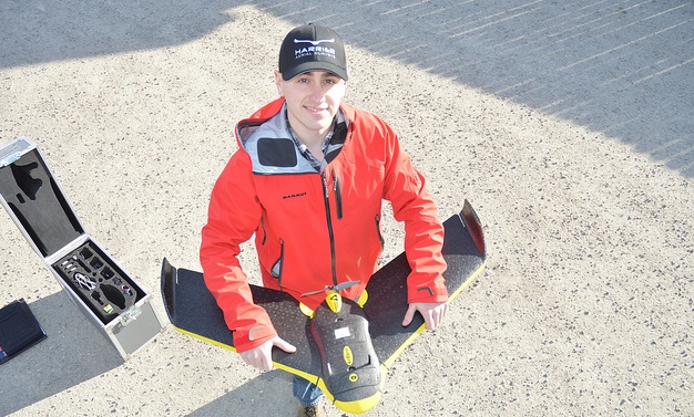
Peter LeCouffe, operations manager at Harrier Aerial Surveys, shows off a fixed-wing drone. — Kerry Shellborn photo
The alarm buzzes at 6:30 a.m. Do you 1) grumble and hit the snooze button or 2) jump out of bed to get to work early with a big grin on your face?
Meet Peter LeCouffe who flies drones. Yup, those cool little unmanned air vehicles (UAVs) you’ve been hearing so much about in the news. Together with Robert Simmerling, LeCouffe is co-owner of Harrier Aerial Surveys, based in Nelson.
With a fixed-wing drone and a multi-rotor one, the company is finding there’s demand for its UAVs because of their efficiency and because the UAVs can fly in tight spots and dangerous places. Diverse applications for the UAVs include terrain modelling in mining, plant stress in agriculture and population estimates in wildlife management.
LeCouffe is a youthful entrepreneur at 25 years old who does rise early sometimes to fly his drones.
His cool career started when he was working on his environmental technology diploma from Camosun College in Victoria and was introduced to GIS (geographic information systems). He continued his education at Selkirk College in Castlegar by earning an advanced diploma in GIS. That’s when he flew his first drone.
With a desire to learn more about working with 3-D data, LeCouffe met Simmerling, who does precision industrial work and introduced him to drone technology. So for his thesis, LeCouffe took on the college campus.
“I flew at the college on a Sunday morning at 6 a.m. when nobody was around,” LeCouffe said. “I flew the whole campus and I created a 3-D model of the whole campus itself.”
“If I were 25 years younger,” Simmerling said, “this is what I would do (for a career).” After working with Simmerling’s data for a couple of weeks, LeCouffe said, “Rob, I’m 25 years younger. Let’s do this.” So they set up Harrier Aerial Surveys in April of 2014.
One of the first major projects that the partners bid on involved calculating the volume of the chip pile at the Zellstoff Celgar pulp mill.
“We were competing with traditional land surveyors that would go around . . . they’d pick up 1,500 (data) points in their eight-hour day,” said LeCouffe, explaining what they were up against in the bidding process. “Once we were set up, in 15 minutes we fly that pile and get 3.5 million points for that one pile,” LeCouffe said.
Needless to say, Harrier got the contract, and LeCouffe still gets excited talking about their success accomplishing it.
With that passion for knowledge, LeCouffe is not idle; he is currently working towards a bachelor’s degree in GIS at Selkirk. And annually he must apply for a Special Flight Operations Certificate from Transport Canada.
“I’m learning new software every week,” he said, “just another way to stay ahead of the game.”
LeCouffe’s job does entail much computer time and quality control of the data. What does he love most about his job?
“The adventure, really,” he said. “It’s been wicked so far . . . problem-solving to figure out exactly how you get something done. . . . Every time I send that (drone) up, my heart gets going.”


Comments