
Selkirk College provides closer look at LiDAR Data Collection Tools
Vernon-based X1 Aeronautics demonstrated its Mobile Terrestrial LiDAR unit that is operated from a number of different platforms
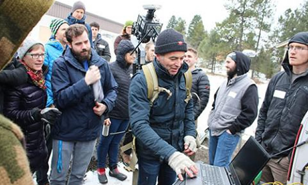
In mid-January at the Selkirk College Castlegar Campus, Vernon-based X1 Aeronautics demonstrated its Mobile Terrestrial LiDAR unit that is operated from a number of different platforms including a portable backpack. — Photo courtesy Selkirk College
As part of its leadership in research designed to advance the adoption of new technology in the Kootenay region forestry and natural resource sectors, Selkirk College hosted a demonstration day that put focus on the latest tools used for geospatial data collection.
The latest data collection and processing technology was on display in mid-January at Selkirk College when students and faculty gathered with representatives from several industries for an afternoon of demonstrations on the Castlegar Campus.
The Selkirk College Applied Research & Innovation Centre (ARIC) put together the demonstration day featuring two of the newest tools used for geospatial data collection. More than 40 people took part in the afternoon that included a closer look at the GeoSLAM Zeb Horizon mobile laser scanner and the Phoenix Mobile Terrestrial LiDAR.
“The technology in this sector is fast changing,” says Kim Green, a researcher at ARIC who helped organize the afternoon. “It was great to pull together students, faculty and leaders in local industry to explore the latest equipment. It was an educational afternoon that made all those in attendance excited about future possibilities.”
Companies on the Cutting Edge
Burnaby-based Cansel came to the West Kootenay to demonstrate the handheld laser scanner known as the GeoSLAM Zeb Horizon that is able to capture 3D spatial data. Equipped with a range of 100 metres, these scanners have a lightweight and compact design that can be used to map complex terrain and forest stands with accuracies of less than three centimetres. With handheld scanners becoming more affordable, they are now being utilized more often for collecting forestry and environmental survey data.
“There were several representatives from the forest industry in attendance and I think they saw how this type of technology can help them do business better,” Green says. “In more remote areas with dense canopy, this unit can be very effective.”
Vernon-based X1 Aeronautics demonstrated its Mobile Terrestrial LiDAR unit that is operated from a number of different platforms including unmanned aerial vehicles (UAV), ATVs and also using a backpack to undertake studies requiring the collection of terrain features and other spatial data.
LiDAR is a surveying method that measures distance by illuminating the target with pulsed laser light and measuring the reflected pulses with a sensor. It is commonly used to make high resolution maps.
Though the use UAVs (commonly known as drones) is becoming more commonplace in mapping, the backpack method on display by X1 Aeronautics allows the LiDAR technology to access terrain when UAV-hosted methods become difficult due to weather or poor line-of-sight visibility associated with complex terrain.
“As this technology becomes more cost effective and accessible at both the post-secondary training and industry level, it’s important that those in the field of mapping and data collection stay current,” says Green. “Both of these companies gave excellent demonstrations of what is out there and what is available.”
Providing Leadership and Innovation
In the Spring of 2018, Selkirk College was successful in securing $2 million in funding from the Natural Sciences & Engineering Research Council of Canada (NSERC) to support research designed to advance the adoption of new technology in the Kootenay region forestry and natural resource sectors. Selkirk College was one of only 10 post-secondary institutions across the country to be provided the funding.
“The goal of our five-year NSERC grant is to build an innovative forestry technology cluster in the Kootenay region,” says Ian Parfitt, the coordinator of the Selkirk Geospatial Research Centre. “Selkirk College has the unique ability to bring students, researchers, technology, and the forest industry together for events like this.”
Learn more about the Selkirk College School of Environment & Geomatics and join us on Facebook.


Comments