
Pointing high school students in the GIS direction
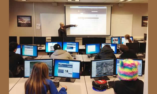
Selkirk student Ezra Buller walked high school students through some of the GIS options.
The Selkirk College School of Environment & Geomatics offers students exciting learning paths and graduates career opportunities. High school students from around the region had the opportunity to learn more about the program last month during GIS Day.
Selkirk College has helped guide some young minds through the tangle of choices they are headed towards.
Selkirk College held GIS Day on its Castlegar Campus last month, opening up new pathways of learning to area high school students nearing graduation. Put on by the School of Environment & Geomatics, more than 30 students visited the campus to learn more about careers related to GIS (Geographic Information Systems).
“I like geography,” said JL Crowe Secondary Grade 12 student Darion Palm. “Today has kind of opened the door to what happens in this program.”
High School Students Keen
Other schools joining Trail’s JL Crowe at Selkirk for GIS Day included Nelson’s LV Rogers Secondary, Castlegar’s Stanley Humphries Secondary, Trail MIddle School and students from the Kootenay Columbia Learning Centre’s Take a Hike Program. Activities on the day included workshops, industry booths and a lunch.
“The students were very attentive,” said Selkirk student Ezra Buller who was helping lead a workshop on applications of GIS technology which included a treasure hunt using Google Earth. “It’s a great program to introduce high school students to because these kids are already centered on their technology. GIS fits well into that world.”
Buller is in his final year of an achieving his Advanced Diploma in GIS. The 39-year-old enrolled in Selkirk College after spending many years in the forest industry. He saw the School of Environment & Geomatics as a great opportunity to further expand his knowledge and pursue his passion.
“This technology is merging into our everyday lives,” said Buller. “It’s neat to be in a field where there are exciting new trends and technology.”
Future is Bright for GIS
Students that passed through Buller’s workshop asked plenty of questions from how much GIS specialists get paid to what types of opportunities await graduates. Buller explained that most graduates find work right after completing their college education and have the ability to work anywhere in the world.
“This program has a nice mix of outdoor and technical abilities which is a nice fit for our students,” said Gareth Cryer, the lead teacher for the Trail-based Take a Hike program. “It’s hard to know what is going to work and what isn’t. But from what I have seen today, it’s piqued the interest for some of our students.”
Selkirk College offers three technical environmental diplomas that lead to an advanced diploma and a Bachelor degree in Geographic Information Systems (GIS). Length of study ranges from two to four years. The program provides specialized training for becoming a geospatial professional with expertise in GIS, remote sensing, 3D visualization and internet mapping technologies.
The GIS Day was co-sponsored by Esri Canada and Columbia Power.
Learn more about Selkirk's School of Environment & Geomatics and join us on Facebook.


Comments