Tales from the mighty Columbia River
A river tour offers views of modern technology and ancient rock forms

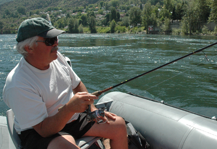
Gary Crombie casts his line while guiding guests along the Columbia River in Trail. — Photo by Tanya Laing Gahr
Before the Teck (formerly Cominco) smelter created a city that at one time was the third largest in the province of British Columbia, before the Trail Smoke Eaters hockey team became a force to be reckoned with around the world, even before the First Nations people fished the waters, there were the mountains and the mighty Columbia River.
The Columbia River is the fourth largest river system in North America with the largest volume on the continent draining into the Pacific Ocean. From source to delta, it is 2,000 kilometres long and, including its tributaries, is the most dammed river on the continent as well. At Trail, it has covered less than one third of the distance it will travel to the sea; but the volume of water is already impressive—and often deadly. But, it can’t be denied, it is also magnificent.
Gary Crombie from Columbia River Power Rafting offered me a trip along the river to see another side of Trail. Starting at the boat launch in beautiful Gyro Park, we set off downstream at a leisurely pace. On one side of the river is the Teck smelter—the largest non-ferrous lead and zinc smelter in the world. Trail has a complicated yet positive relationship with the smelter, and much has been said over the course of its 110-year history about environmental damage. But as we floated past, Crombie pointed out how clean the river was. By way of proof, as we drifted with the current, Crombie baited a hook and cast his line into the river.
We passed under two bridges, generally known as the old bridge and the new bridge. Before major damming and flood control, the waters of the Columbia could rise so high as to touch the bottom of the old bridge, which in June was about 20 feet above our heads. It’s a daunting image.
Beyond city limits
As we left developed Trail behind us, we got into some serious nature. It’s common to see native wildlife along the river—elk, whitetail deer, black bear and otters are regularly spotted. And the fish, of course, though they weren’t biting today—a rarity, according to Crombie. He pointed out the folds of rock—volcanic—that brought European settlers to the area in search of gold.
The current is fast but the pace is relaxing. Crombie continued to fish (unsuccesfully) while we chatted. In between pointing out various landmarks, fish flipping beyond Combie’s hook, signs of industry or natural erosion, we engaged in a discussion about how you would explain “heebie-jeebies” to someone whose first language wasn’t English. The weather was hot and Jimmy Buffett was playing on Crombie’s MP3 player.
Rock (and roll) Island
The highlight of the trip is Rock Island, which is exactly what it sounds like. The Columbia narrows and bends and in the middle is a large rock formation where the fast-moving but placid river suddenly becomes turbulent, choppy and just a little unsettling. When sternwheelers were making regular journeys from the United States, 10 kilometres to the south, they had to be hauled by a winch through the narrows. It’s here that we get to see what the power raft can do. Crombie revs the motor and we careen through waves, skirting maelstroms and eddies. As we looked at the whirlpools that are caused by the water curling around the island, we all got a very good sense of how to describe heebie-jeebies. But the ins and outs, ups and downs are so thrilling that we took several turns through it before gunning the engine and heading back up stream to the boat dock.
When we disembarked back at Gyro Park, I’m certain Crombie was turning around to go find the fish that eluded him on our trip. Crombie, who grew up in Trail, considers the river to be the most integral part of the city. While modern day economics would say the smelter has shaped the city’s culture, Crombie believes the river is the greatest influence. For him personally, that much is obviously true.


Comments