Mapping a route to success
A brother duo from Trail has released their established mapping guidebooks on a GPS platform

The two brothers knew they made a hot business product when every single book sold at their first trade show in the Lower Mainland — Photo courtesy of Russell and Wesley Mussio
Maps are a handy thing to have around when trekking around in the backcountry.
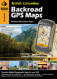
For Russell and Wesley Mussio, their passion for the outdoors drove them to map out all the different kinds of recreational opportunities in British Columbia and conveniently present the data in a book. After expanding to cover the rest of the country, their company, Backroad Mapbooks has gone digital, converting the data and making it commercially available for handheld Garmin GPS units.
It's taken a long time to get the data conversion process and jumping into the digital GPS is a new field for Russell, who is used to gathering material for print editions, which is more of a visual exercise.Now that GPS units have moved into the mainstream, retailers and consumers have been asking for a way to get all the data from the map books into their GPS devices, according to Russell.
"People can buy right in the store and go out to their little Garmin and slide it right in and the maps and actual writing pop right up," he said. "You can either simply look at the maps or you can use the search features of it to search for various recreational activities that we've discovered for our map books that we've just transfered over."
The difference with GPS and printed maps is that GPS data is much more specific than what you get from a book, he said.
The beauty of the Backroad Mapbooks is that they contain all kinds of useful data from paddling routes, backcountry trails and fishing spots, instead of just narrowing in on one activity type.
Russell started the company with his brother 17 years ago when he researched the idea of starting a publishing company that mapped out B.C.'s backcountry for his thesis at the University of British Columbia. He discovered that there was no product that combined all the different kinds of backcountry recreation in one guidebook or map. Armed with his degree in leisure and sports administration, coupled with his brother's background as a registered professional forester and lawyer, the two pooled their skills and a dream was born.
They bought a printing press and put it in Wesley's garage and began the process of gathering all the field data. One employee was hired for mapping, followed by another, and then a salesman was brought on and business took off from there. They started with regions like Vancouver, Vancouver Island and the Okanagan until they'd covered the entire province.
The two knew they made a hot business product when every single book sold at their first trade show in the Lower Mainland.�Russell credits their passion for the outdoors to growing up in the West Kootenay community of Trail, where there was always plenty of opportunity hiking, hunting and fishing.
He says listening to customer feedback and hiring the right people are the two key factors that have led to the company's success. A solid network of contacts in places like the government and outdoor fishing, hunting and hiking clubs was also instrumental in mapping out all the features they wanted in their product.
Backroad Mapbooks has expanded to map out Alberta, the prairies, Ontario, Quebec and the Maritimes following the success in B.C. and have roughly 1.5 million books in circulation.


Comments